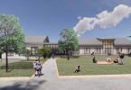
Aerial view of Moakley Park / ©2019 Stoss Landscape Urbanism
Boston – Moakley Park, a 60-acre community park in South Boston, floods regularly — even minimal rain events cause the playing fields to become unusable and unsafe.
Coupled with the fact that Boston’s largest waterfront park sits at a critical breach point for South Boston and with a projected 21-inch to 36-inch in sea level rise, the park becomes a major flood pathway inundating adjacent neighborhoods, including two low-income housing developments.
With this reality in mind, City of Boston Parks and Recreation Department and the Environment Department commissioned a vision plan for the park that would not only address critical climate resiliency issues, but would turn Moakley Park into an exemplary 21st century open space with a focus on equity, diversity, community, and, of course, enviable recreational amenities.
Stoss Landscape Urbanism , along with partners One Architecture and Urbanism (ONE) and Nitsch Engineering, recently completed the vision plan, delivering an exceptional opportunity to transform this park into a model for Boston (and similar cities) and to expand thinking on how conventional park models can become multifunctional open spaces, all while addressing climate change needs.
Accessible to a wide range of Boston’s population, the park is served by two train line stops and boasts highway access for visitors from across Boston and the region. With this in mind, the design team conducted in-depth analysis to understand site opportunities and constraints through site visits, local planning documents, flood maps, ownership, existing vegetation surveys, and recreation analysis.
In addition, community engagement was of paramount importance throughout the duration of the project, including a series of open houses and onsite events. According to Allison Perlman, project manager, Boston Parks and Recreation Department, “The community was involved every step of the way, in thoughtful events that served to collect input and generate excitement for the project.”
The vision plan addresses three key goals. Firstly, it includes smart resiliency methods that protect the park, the neighborhood, and the city from climate change and sea level rise. These methods include:
- Flood protection berm and raised landscapes that protect the community and provide recreational opportunities (sledding hills!) as well as visual access to the waterfront.
- Large underground chambers beneath recreational fields provide almost 5 million cubic feet of subsurface storage for stormwater management.
- Ecological strategies including stormwater wetland systems.
- Porous pavement in parking areas.
- Offshore breakwater and living shoreline wetlands attenuate wave action and seed new habitat.
- Massive tree planting counters urban heat island effect.
- Swale systems along adjacent streets that provide an additional 700,000 cubic feet of storage.
Preliminary calculations indicate that these storage volumes could collect, infiltrate, and detain storm events up to the projected 16-inch or 500-year rainfall event in 2100 as described by the Boston Water Sewer Commissions “Wastewater and Storm Drainage Facilities Plan,” published in 2015.
Secondly, the plan modernizes existing athletic facilities, layering in new programs and flexibility to attract and diversify visitors, all while adding robust planting to make the park more ecologically varied. The upgraded sports facilities create premier fields through improved field layout, lighting, and integrated stormwater management while also offering harbor views. The fields and sport courts are organized into the following primary areas: softball and little league fields, baseball field, track and field, sport court complex, and soccer and multi-use fields.
Embedded in these areas are numerous additional opportunities for active play, including an adventure playground, sledding hill, BBQ area, flexible fields, water play area, field houses with community space, and a waterfront café offering a premier location for events or just relaxing with refreshments after a game.
Lastly, the plan considers how to create equitable access to Boston’s harbor and build a diverse and active community. By increasing the linkages and relocating access points into the park to key intersections, the plan serves to improve accessibility and connectivity. The central-most point of access connects directly to the adjacent low-income housing development and brings visitors to the harbor through a long sloping ramp, at the top of which visitors enjoy an expansive view of the harbor and the islands. In later phases of the plan, Day Boulevard, which currently acts as a barrier to the beach, can be shut down to traffic and transformed into a waterfront promenade.
The design team provided the city with an implementation road map, suggesting next steps to continue the project through construction with suggestions on funding strategies, phasing, and additional studies required to fully realize the park. Chris Reed, founder and design director at Stoss, says, “This plan is exciting because it demonstrates the expansive range of roles landscape architects play in the shaping of equitable and climate-ready cities, spanning the realms of analysis, planning, community engagement, design, and implementation planning”.
As the city of Boston continues to be a leader in climate change adaptation, the Moakley Park Vision Plan will set a standard for comprehensive park projects that innovatively enhance community open space through flood infrastructure.