Boston – The Boston Zoning Commission approved a zoning overlay requiring new development and retrofits to take additional steps to limit the damage and displacement related to the impacts of coastal storms and sea level rise. This marks the final step in the approval process prior to the mayor’s signature.
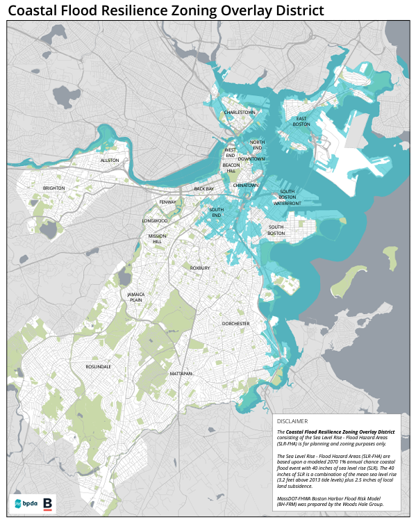
The Coastal Flood Resilience Zoning Overlay District, goes beyond the areas identified in FEMA flood maps, applying to areas of the City that could be inundated during a major coastal storm event, known as a 1% chance flood event with 40-inches of sea level rise. Fulfilling steps outlined in Climate Ready Boston, the Boston Planning & Development Agency (BPDA) Board of Directors approved this new zoning overlay in September. The zoning overlay promotes resilient planning and design, provides consistent standards for the review of projects, and maximizes the benefits of investments in coastal resilience.
Based upon climate modeling, 40-inches of sea level rise is expected around 2070, which is within the usable life of most buildings currently undergoing BPDA review. The 40-inch inundation area is integrated into the BPDA Zoning Viewer.
The Zoning Overlay, Article 25A of the Boston Zoning Code, will provide new definitions and standards for building dimensions and uses to facilitate flood resilient design for new projects and building retrofits. Intended to prevent flood damage by elevating building occupiable space, flood proofing areas beneath flood elevations, and promoting health and safety by preventing uses such as living space below the flood elevation, the specific provisions of the overlay include:
- Building Height: Projects undergoing Resilience Review will have their height measured from two feet above the Sea Level Rise Base Flood Elevation (SLR-BFE), rather than at grade, which is what current zoning requires.
- Building Setbacks: Projects will have allowances to extend into side yard, rear yard, and front yard setbacks for structures needed for vertical circulation, such as stairs or ramps to get from surrounding grade to a higher first floor elevation.
- Lot Coverage and Required Open Space: The structures needed for vertical circulation and mechanical systems referenced above will be excluded from measurement of lot coverage and open space
- Gross Square Floor Area: Will exclude structures needed for vertical circulation and areas devoted to flood protection measures. Limitations on Use Below the Sea Level Rise Design Flood Elevation: For health and safety purposes, uses beneath the SLR DFE are limited to access for vertical circulation structures; flood prevention measures, storage, and parking.