By Christopher Lorrain, PE
Christopher Lorrain
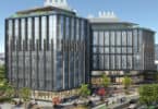
New England has long been known as the hotbed of higher education. Colleges and universities work diligently to attract the best students, faculty, and industry partners by investing millions in technology and new construction to constantly improve the quality of education and campus life.
Yet, more often than not, the technology available to make new construction more cost-effective and efficient are overlooked for the traditional planning, construction, and facilities management techniques we’ve been using for decades. We often remain stubborn Yankees rather than embracing the tools that foster better design and faster construction.
Most people think building information modeling (BIM) is only a tool to be utilized during the design process for new construction. But construction in our region goes beyond the benefits of utilizing BIM for new buildings. In fact, most of our “new” construction is renovation or additions to existing structures. And in order to utilize BIM effectively, you need to create a BIM model of the structure to be renovated. How do you get real-world accuracy of an existing structure without breaking the bank? 3D laser scanning creates a fast, accurate, and detailed digital picture of existing conditions. Buildings can be documented in a virtual point cloud that can then be modeled into a very accurate existing-conditions model from which to base the new design.
Mechanical rooms, piping, HVAC, fire protection, elevator shafts, just about anything that traditionally have been difficult to locate with marginal accuracy can be located, mapped, and modeled to millimeter accuracy utilizing laser scanning. That retrofit of your mechanical room or boiler replacement just got a lot easier and faster with the ability to plan exactly what needs to be removed and replaced, not to mention prefabricate. It creates the ability to see how construction is going to proceed before it happens.
Why does BIM have to stop at the front door?
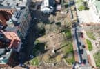
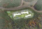
What if all of the campus infrastructure were in an accurate 3D BIM model to assist in planning of new buildings, sports facilities, open spaces, parking lots, even facility management? This ability exists today with the combination of 3D laser scanning, traditional surveying, and 3D modeling.
Complete campus models of existing conditions can be created with above- and below-ground features accurately shown by combining the old and the new to create an extremely useful platform for effective planning. For instance, a recently completed interior and exterior laser scan and model of a distinct building at a private secondary school in New Hampshire led to a geothermo project once the client saw what they could “see” through the 3D laser scanning and modeling project. The geothermo project involved drilling many geothermo wells throughout the property.
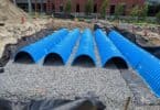
Underground tunnels traverse areas of the campus from building to building. Even with thorough planning, well installations hit the tunnel not once, not twice, but on three separate occasions. Imagine the savings that would have occurred if the tunnel had been properly located utilizing 3D laser scanning and conventional survey technology, then modeled in relation to the rest of the campus prior to laying out the drilling pattern. Add in the numerous underground utilities and the lost change orders, and reduction in time to completion would have paid for the upfront modeling many times over.
Combining 3D laser scans of the existing conditions with the vision of new buildings and layouts gives the ability to virtually see the reality of the concept. The ability to create detailed 3D models of real-world conditions on a campus infrastructure level allows planning and development projects to proceed at a rapid pace with few surprises, resulting in minimizing disturbance to ongoing activities, substantial cost savings, and the ability to clearly present design intentions. By embracing today’s technology we literally can see into the future.
Chris Lorrain is president of LandTech Consultants, Inc.